|
Purpose:
This study assesses the eleven tracts of state land on the Lake
Michigan shoreline of Beaver Island, Michigan, and proposes short-
and long-term plans for each. The entire 32-page report is available
in the public library and township offices. It has been distributed
to local government bodies and voluntary organizations, and can
be made available to other individuals and organizations that
need ongoing access for their own plans and programs.
These public lands on Beaver Island are a unique public resource
of scenic beauty, outdoor recreation potential, and ecological
preservation. Properly cared for, they are part of the potential
for Beaver Island to be a natural wonder of the area, both preserved
and enjoyed for generations to come.
The full report contains a set of GIS maps and overlays provided
by the Central Michigan University Biological Station and the
Charlevoix County GIS office, as well as other maps and satellite
photos adapted for this study. Some are available on the county
web site. The full display for each tract includes topographical
maps, satellite photos, aerial photos, and on-site photos. A limited
selection is reproduced in this summary. The assessment and recommended
plans for each site are based on the fuller data set.
Shoreline Tracts in the Study:
GIS overlays of wetlands, drainage, and topography, as well as
satellite and high-altitude aerials of the Island, are in the
full report. The summaries presented below and on the following
pages condense the discussion of the features and plans for each
tract. GPS coordinates are also omitted here.
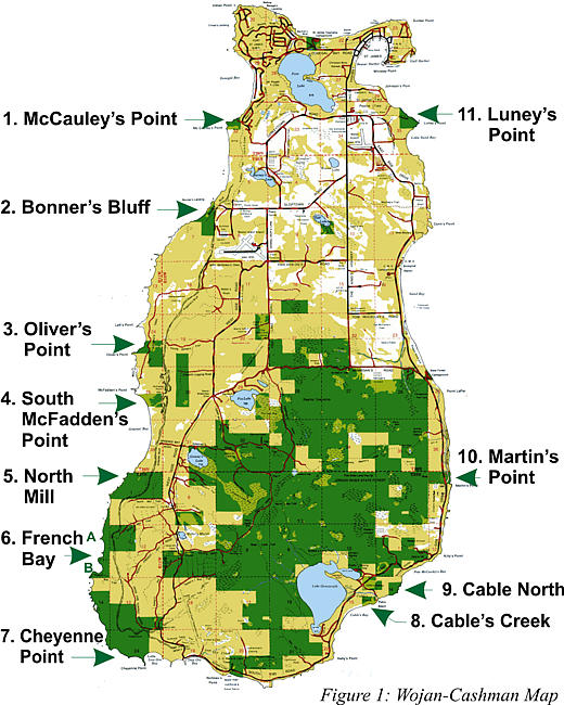
The adapted Cashman-Wojan map (Figure 1) identifies the tracts
beginning in the Northwest corner of the Island and moving counter-clockwise.
|
|
|
Click
on any Tract on the Map above (or the list to the
left) to see details on that Tract
|
|
Approximate dimensions are in east-west and north-south directions
with straight-line shoreline estimates.
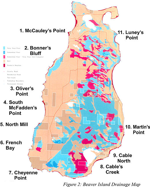
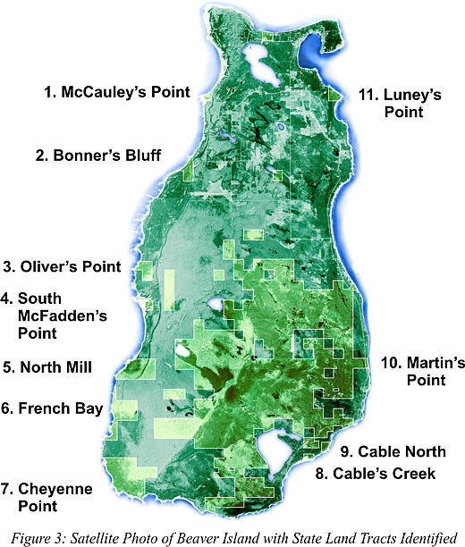
The topographical features identified on the Terraserver satellite
photo (Figure 3) show the Island to be relatively flat. There
are major dune areas on the northwest shoreline around Donegal
Bay, on the west side at McFadden's Point, and at the south end
around Iron Ore Bay, along with other smaller dune sites. Wetlands
are found throughout the Island with concentrations tied to inland
lakes. Upland forests are primarily on the west side and lowland
on the eastern half. Critical soil drainage is also found primarily
in the eastern half with major marshland adjacent to Lake Genesereth
and a string of inland sites mostly up the center of the Island.
For the purposes of this study, it is significant that the ecologically
fragile areas are, for the most part, not on the public shoreline
tracts. The two exceptions are the two major dunes. There are,
however, site-specific localized areas subject to changing conditions,
sometimes from beaver activity. Miller's Marsh is a fragile area
under study by CMU.
Other Public Shoreline Tracts: Several other public sites include
two campgrounds, two lighthouses, and three beaches. More recent
development is at Gull Harbor and the Whisky Point Lighthouse.
Timetable:
The project was proposed and approved by the Beaver Island Property
Owner's Association in the summer of 2002. It was further endorsed
by the township boards and Chamber of Commerce. Dr. James Gillingham,
Director of the CMU Beaver Island Biological Station, supported
the grant application, provided available Island overlays, and
agreed to further support by station faculty. A grant was awarded
by the Great Lakes Aquatic Network and Fund of Petosky, Jill Ryan,
Director. This has primarily supported publications costs for
the Draft and final reports. In the spring and early summer of
2003, sources of data were further identified and various GIS
themes combined. CMU summer faculty Drs. Beth and Ed Leuck provided
on-site evaluations and photographs. Aerial photos were taken
by Jeff Cashman from the Kelly Cessna. A draft report was produced
and distributed in late summer 2003 for comment by Island organizations
and government bodies, state agencies, and other organizations,
especially those with expertise on freshwater land-water habitats.
A public hearing was advertised and held in late summer.
Comments and suggestions have been incorporated into the final
report coordinated by Dr. John R. (Jack) Kelly, Professor Emeritus
of the University of Illinois at Urbana-Champaign. Summer address:
Box 382, Beaver Island, MI 49782. Phone: 231 448-2524. E-mail:
jr-kelly@uiuc.edu.
Particular thanks are due to Drs. Beth and Ed Leuck of Centenary
College and CMU, Dr. Jim Gillingham, Erin McDonough who assisted
in the inauguration of the project, Jeff Cashman for photography
and formatting, Chris Blough of the Charlevoix County GIS office,
the Beaver Island Property Owners' Association, Pam Grassmick,
President, and especially Jill Ryan and the Great Lakes Aquatic
Network and Fund. This public land is a resource of incalculable
value to the Island and the state. Careful planning by the Island
townships, the county, and the state can allow Beaver Island to
be a model of preservation and recreational enjoyment. The tract-by-tract
summary suggests how this resource can be loved and shared in
ways that will continue to attract visitors and residents to this
wonderful place.
Possible Priorities:
- Continue to work with volunteers to locate, clear, and sign
existing trails. A beginning has been made in locating current
trails with GPS coordinates and trailhead signs. The combination
of township and voluntary engagement is an excellent model.
- Bonner's
Bluff beach: Pursue plans to obtain public access to this
lovely site near town.
- French
Bay: Develop an access and site plan for this special south
end site.
- Luney's
Point: Restore the walking trail and explore possible harbor-view
picnic sites.
- Martin's
Bluff: Monitor use and impacts on the high dune.
These and other priorities should be part of an overall plan,
for which this study can provide a base.
If Island residents are serious about both conservation and a
measured development of the second-home and tourism economy, such
a comprehensive plan should be supported through the channels
of the voluntary organizations and public officials. MDNR cannot
be expected to take the lead in this process due to staff and
funding limitations.
The Real Beacon:
Search the Beaver Beacon Web Site & Archive:
|